The EcoAngler Report
Planning a trip to the East Fork Carson River? Get scientific based angling intel in The EcoAngler Report - East Fork Carson River.

Detailed information on the East Fork Carson's native and wild trout populations along with a map and directions to access this undammed river can be purchased here.
An Adobe PDF document will be made available with your $2.95 purchase. Select Return to the Ecological Angler to view and save your purchase.
Directions
From Sacramento Drive east on U.S. 50 to the junction with Highway 89. Turn south on Highway 89 and drive over Luther Pass to the junction with Highway 88. Turn left and drive to Woodfords and Highway 89. Turn right onto Highway 89 and drive throught the town of Markleeville. Continue past Markleeville to the junction with Hwy 4. Continue straight on Hwy 4 for 3 milies to Wolf Creek Rd. Turn left and cross Silver Creek bridge. Proceed up hill and the road will transition from paved to dirt. As you reach Wolf Creek Meadow, the road leads off to the left. Turn there and proceed over Wolf Creek. Continue on the road until you reach the parking area for the High Trail and East Carson River Trail trailhead.
Silver King Creek
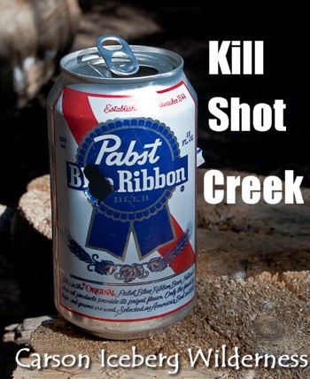
California's Department of Fish & Game is leveling a kill shot at Silver King Creek - a major trib to the East Fork of the Carson River. The EcoAngler visits this water before the planned removal of the non-natives.
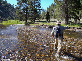
Fly Fishing the Carson Iceberg Wilderness
Another part of the East Fork Carson River, from Wolf Creek upstream to Carson Falls, is also a designated Wild Trout water. Access to this part of the river is mostly from foot trails into the Carson Iceberg Wilderness.
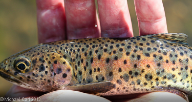
Trout Species
The East Fork of the Carson upstream of Wolf Creek doesn't see much angling pressue largely due to it's isolation (i.e., lack of road access). Without roads, it's out of reach for the hatchery trucks, and results in a solid population of rainbow trout, a small number of wild brown trout, and the possibility of a wild Lahontan cutthroat. Similar to the lower stretch of the East Fork of the Carson River, rainbow trout predominate here and will generally run smaller - between 6 to 10 inches in length.
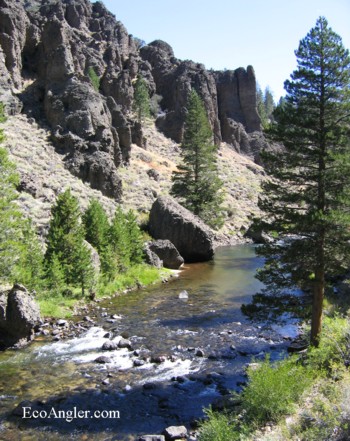
East Carson River Trail
One option for getting to a remote stretch of the Carson River is the East Carson River Trail. The East Carson River Trail leads into the Carson-Iceberg Wilderness from the High Trail/East Carson River Trailhead. Both trails begin at the same point. The East Carson River Trail is more gentle, but longer than the High Trail. There is a sign post at the first fork showing the East Carson River Trail to the left, the High Trail to the right. Continue along this clearly visible trail past Wolf Creek Lake. Stay right at the next fork to remain on the East Carson River Trail ( The trail to the left goes to Grays Crossing, a favorite fishing spot and continues along an old jeep road to Vaquero Camp and Silver King Valley ).
The East Carson River Trail to the junction with the High Trail is about eight miles long. A loop heading up the High Trail and returning by the East Carson River Trail is often favored by horseback riders and hardy day hikers. The distance is about 15 miles with some strenuous hiking up the High Trail.
The trail continues to Soda Springs guard station, Falls Meadow, Carson Falls and Golden Canyon. There are no river crossings until about a half mile before Soda Springs.